|
Photo Album Maps & Atlases >
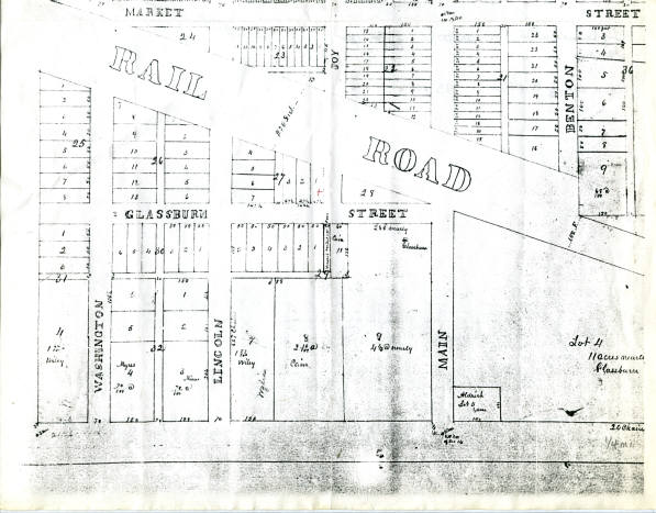
Tampico City Limits - Southwest
Tampico City Limits - Southwest
Street map of the southwest section of Tampico. Unsure of year, but this still shows the old CB&Q RR tracks.
Exerpt from Whiteside Co. Portrait & Biographies 1885
CHICAGO, BURLINGTON & QUINCY RR
This company completed its branch road, known as the Clinton & Mendota Branch of the Chicago, Burlington & Quincy (No. 6), through the county (Whiteside) in 1872. It enters in the southeastern corner of the county and runs through the townships of Hahnaman, Tampico, Prophetstown, Lyndon, Fenton, Union Grove and Garden Plain to the Mississippi, opposite to Clinton. After many years of struggling, this company secured their right of way into Fulton. They obtained their right of way across the Nowrthwestern track Dec. 25, 1882. In the month of January, 1883, they completed their track and ran their first train into Fulton.
This company also owns the road from Rock Island to Sterling, known as the Rock Island & St. Louis Branch of the Chicago, Burlington & Quincy. This road was completed through the county in January, 1869. It leaves the line of the Northwestern a few miles west of Sterling and runs southwest along Rock River, passing out through the lower part of Erie Township.
This company controls, under a lease, the road from Rock Falls to Aurora, by way of Amboy, crossing the Illinois Central at the latter place. In order to make this line available, the company constructed a bridge across the river to Sterling.
TAMPICO AREA HISTORICAL SOCIETY - MUSEUM - FAMILY HISTORY LIBRARY/RESEARCH CENTER 119 Main St., P. O. Box 154, Tampico, IL 61283 www.tampicohistoricalsociety.com tampicoareahistory@gmail.com We are an all-volunteer organization so your donations are always appreciated! Sign up to receive our e-newsletter. Thank you! Visit us on FACEBOOK.
|